
❋
Ranches, Luxury Homes & Estates
Farm & Timber Acreage
Development Parcels
A LandVision360 excels at making large, complex properties pourable, including multi-parcel offers for development. Click here to try out a LandVision360 tour for yourself.
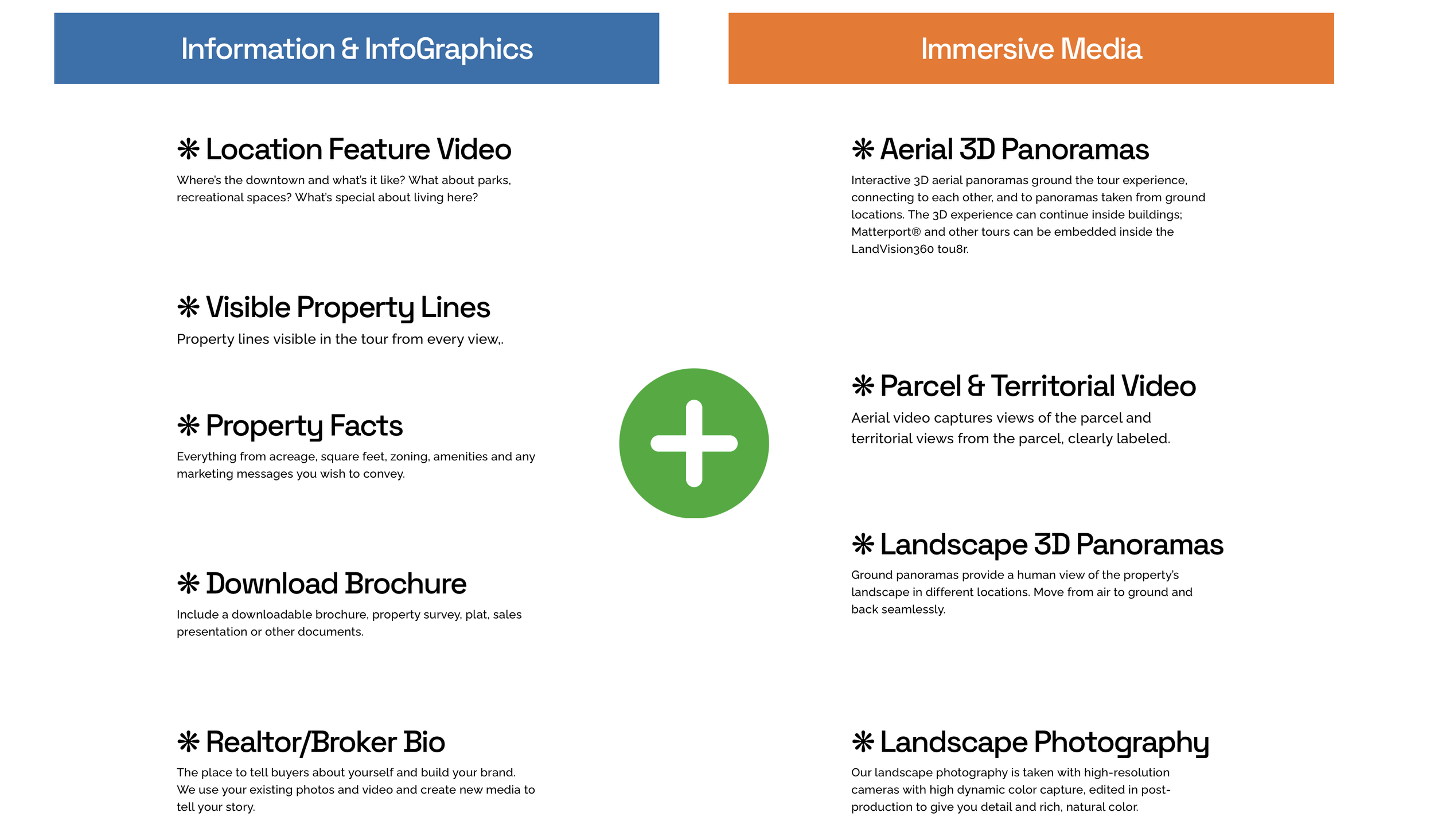
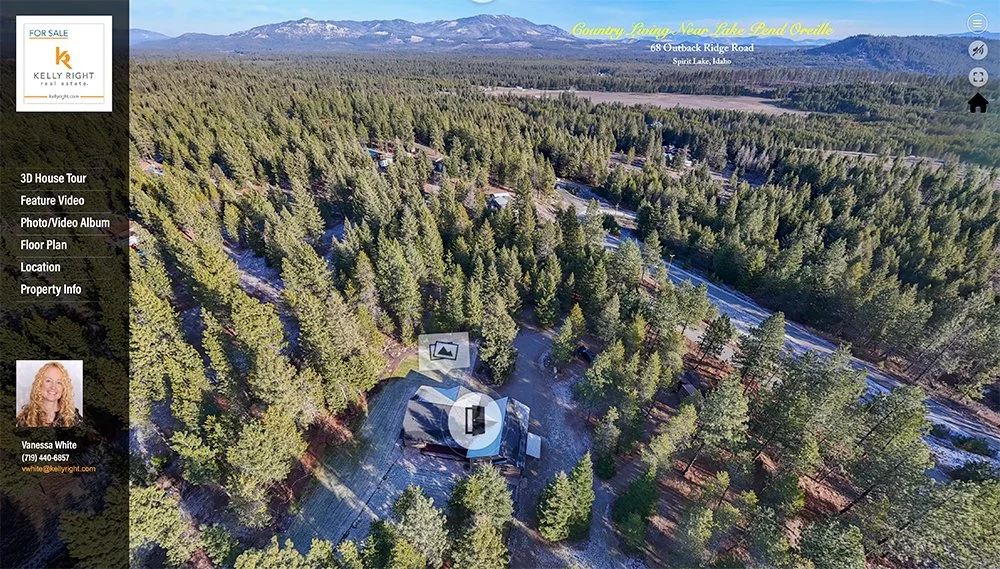
LandVision360 is a 3D tour-oriented website dedicated to ranch, estate, and farm acreage that can capture every detail of a property from 10 to hundreds of acres.
LandVision360 was designed and built by Latitude & Light Photography on a powerful 3D visualization platform, exclusively for use by realtors and land brokers.
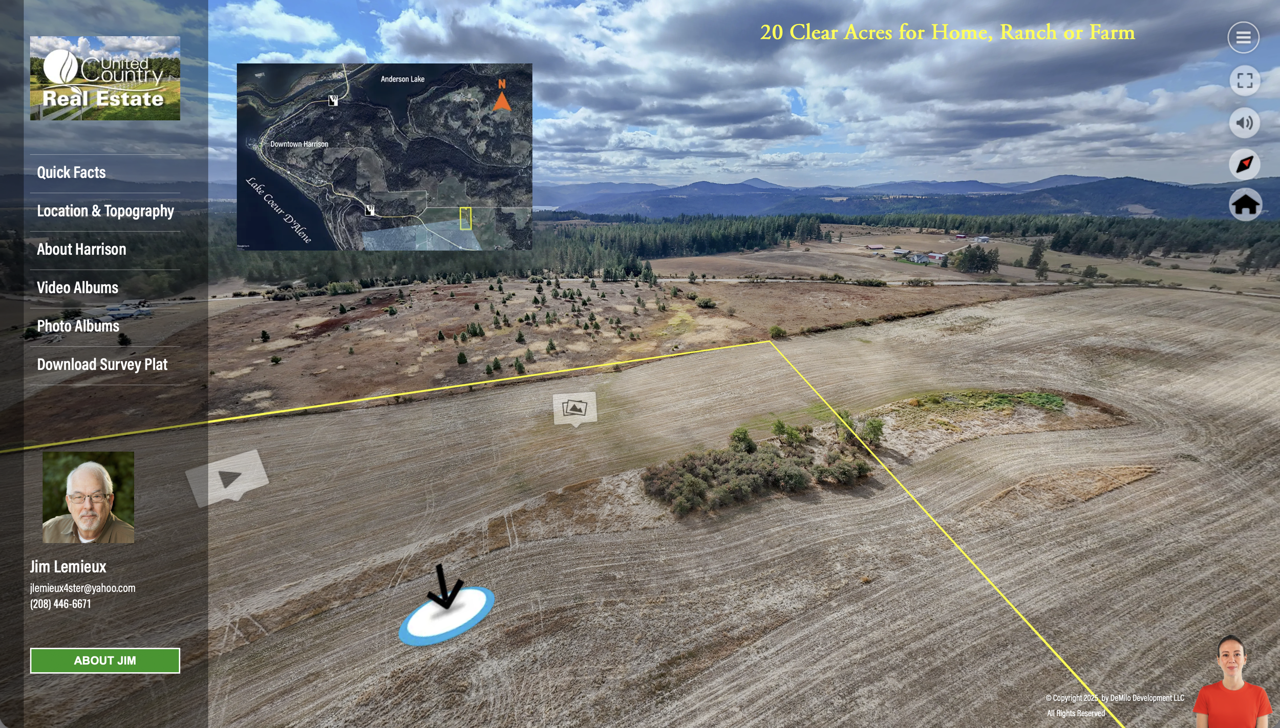
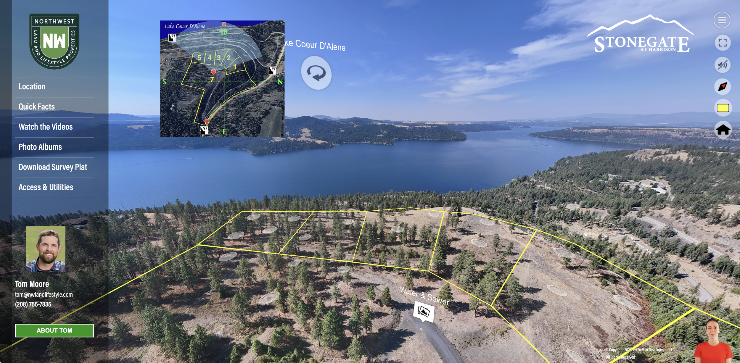
Every LandVision360 tour features a single or multi-parcel property for sale and offers a 3D tour experience from the sky to the ground, even inside buildings. Matterport® tours can be embedded in a LandVision360 tour.
As you move through panoramic views, you can view photos and video shot from different locations, while a radar compass shows where you are and in what direction you’re looking.
Wherever you are, property facts, survey documents, contact info and a feature video of the property location are always one click away.
Device Compatibility
LandVision36 tours run in Safari and Chrome desktop PC & Mac browsers, and IOS and Android mobile devices. The larger the screen, the better the experience.
Support for viewing on VR platforms (AppleVision) is available on request.
Let’s Break Some Rules.
Who says marketing land is about posting a few photos, a map and a video clip?
Don’t limit your exposure of large properties and acreage with small boundaries.
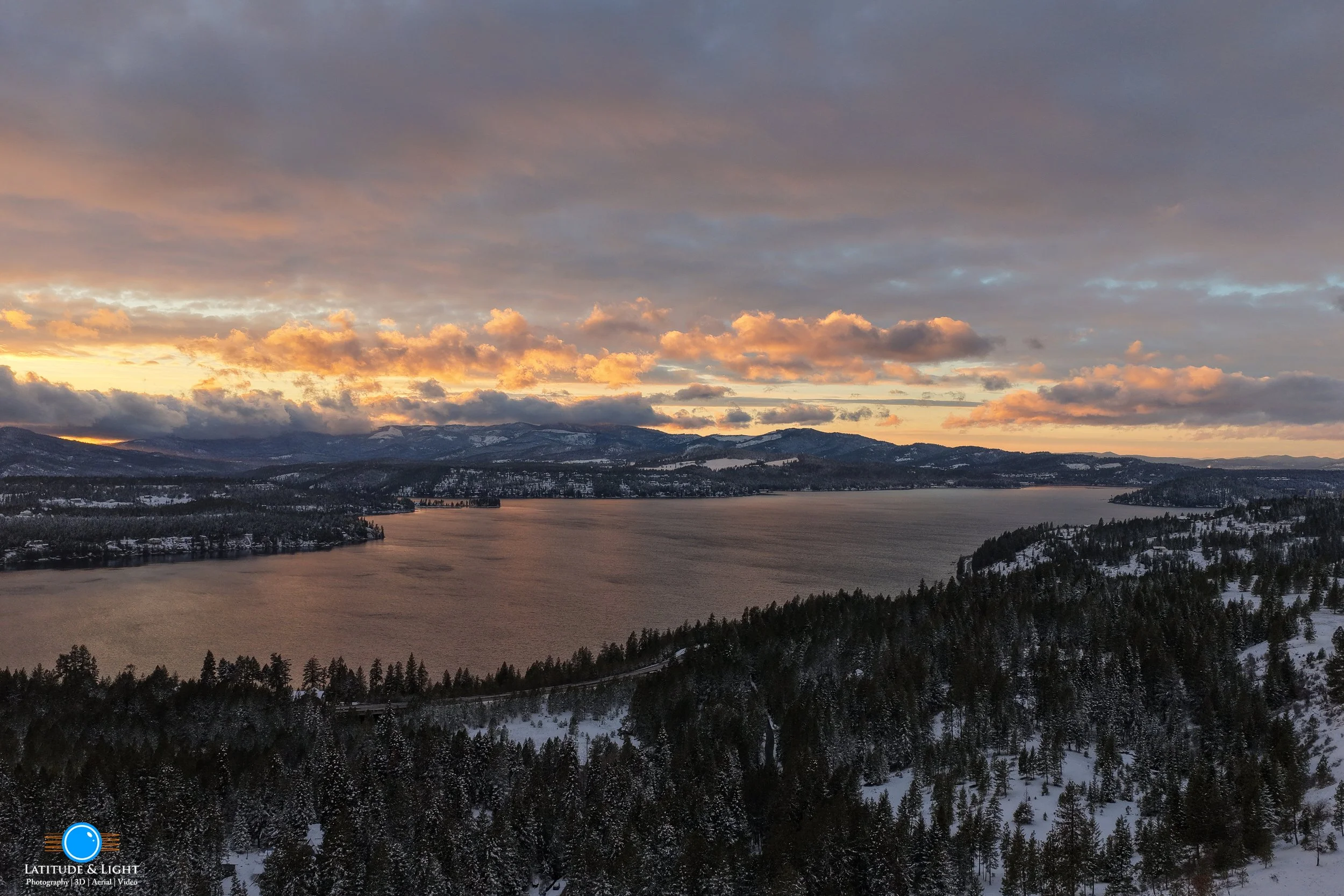
Tell a story. Open a window and let your buyer climb through it to explore tens to hundreds of acres – everything in the sky and on the ground.
We’ve been working with land brokers on acreage and development parcels for over two years to communicate the value and opportunity of land in more creative and engaging ways. For example, we created a less expensive way for land brokers to publish narrated video ads that capture the total story of a land parcel.
Then one day a client asked, “Is it possible to do this for really large parcels like a tour but let the buyer navigate it? See it like a bird?”
From our experience producing 3D virtual tours, we knew the answer was “yes.” But nobody was doing it, and it would require some building a software platform to make it cost effective. We went to work and fleshed out some basic principles for the product, which we launched in August 2025:
See the Whole Thing. Start with a bird's eye view, from different angles.
Fly where you want. Let the bird fly to other views in the air, on the ground, in a building.
Know Where You Are. You can get lost on big land. Make sure you have a compass.
Know What You’re Looking At. View photos and video taken from various locations.
Information Follows You Around. Make sure property facts, plats and contact info are available anywhere in the tour so you can see it without losing your place, when you need.
Realtor/Broker Presence. Make space for branding so the buyer can get to know you. Make the tour available in branded and MLS-compliant versions.
The structure and interaction design of a LandVision360 tour creates a full visual experience of any large or complex property – without exhausting the viewer.
Watching video is a time-bound, linear experience: the information and imagery require a viewer’s attention for the duration of the video. In a time of short attention spans, that limits the effectiveness of videos to 1-2 minutes – and large properties need more time than that to shine.
A LandVision360 tour allows your buyer to discover a property at their own pace and absorb nuggets of information along the way.
What’s Inside a LandVision360 Tour?
Take a LandVision360 Tour …
The Process
-
1-hour meeting to discuss the property, target audience, land features and challenges, desired shot call outs.
-
Aerial and landscape photography depends on the good graces of mother nature. We decide on a target 3-hour slot and a backup.
-
Immediately after booking, send us your logo, bio, property facts, marketing messages and taglines you want to use, along with surveys, plats and any other documents you want to use.
We will set up the tour framework with that content so you can review it before the shoot date.
-
If interior access to the land is not required, you don’t need to attend. But we hope you will, so you can see what we’re shooting without delay.
We also learn a lot on site walking around with the seller - perspectives and information that doesn’t come across in emails.
-
You don’t have to wait for the tour to get your listing up and running.
MLS-ready listing photos will be released within 24 hours after shoot in a dedicated gallery. You control access. Keep it private, share it with colleagues, or open it to the public with a a link.
The gallery organizes photos by categories for easy viewing and includes a slideshow.
-
We color grade and editor raw video into 1-minute clips, and organize the photos for the tour, place and link all the panoramas, compose the Location Feature video, which includes a Google Earth 3D plat and flyover.
We’ll send you the tour for review within 2-3 days, depending on the size of the project and the amount of video shot.
-
The tour will be released with two unique URLs:: one MLS-compliant, the other with fulll branding. You will also receive:
Location Feature Video as an MP4 file for streaming on websites and social media
QR code linked to the tour for use on signage and print collateral
Press quality PDF of the downloadable brochure